Wednesday, April 26, 2017

Moving on up!


We’re moving our Lens & Pen Press blog from Blogger to Word Press and will consolidate the two current blogs into one for our books--the Beautiful and Enduring Ozarks, the James Fork of the White (coming 2017), Damming the Osage, Mystery of the Irish Wilderness and See the Ozarks--and many other favorite topics of discussion like the Ozarks or water resources.

The archive of L&P posts is still available at http://lensandpen.blogspot.com/ 

The posts on our separate Damming the Osage website remain available at http://www.dammingtheosage.com/the-blog/

--------------------------------------------------------------------------------------------------------

COMING IN 2017: JAMES FORK OF THE WHITE: Transformation of an Ozark River.
Sample pages from this new book can be seen at www.beautifulozarks.com

Our earlier ‘river book,’ DAMMING THE OSAGE, can be seen at www.dammingtheosage.com


Saturday, March 25, 2017

TABLE ROCK - BLUFF AND DAM

 
April 2017
  
“Table Rock Dam will be built across the big sandbar.” 
Real photo postcard, 1920s, by Payne Johnson, Branson, Mo.

Shortly after Empire District Electric built Powersite Dam across the White River, creating Lake Taneycomo, the big electric company announced plans to build a 200-foot dam upriver at Table Rock Bluff.

Most bluffs along Ozark rivers are named. Table Rock Bluff had a relatively flat top and was accessible by road. A visit to this overlook was on many vacationers’ itinerary.  For decades locals anticipated seeing machinery in the valley below building a huge dam.  That this never occurred frustrated dam supporters and led them to question if the utility really intended to proceed. They didn’t.
The Army Corps would build Table Rock Dam many years later but the Corps didn’t build it at Table Rock. They moved the location two miles upstream to a more stable geological site, but kept the name.  Table Rock Bluff remains a popular scenic overlook, but is now fenced for safety – unlike the past as shown here.

COMING IN 2017: JAMES FORK OF THE WHITE: Transformation of an Ozark River.  
Sample pages from this new book can be seen at www.beautifulozarks.com 
Our earlier 'river book,' DAMMING THE OSAGE, can be seen at www.dammingtheosage.com


Friday, March 17, 2017

POWER TO ST. PATRICK AND THE SHAMROCK

-->
POWER TO ST. PATRICK AND THE SHAMROCK

Bishop Rice has dispensed

Catholics in the Springfield-Cape Girardeau Diocese

from abstinence from meat

St. Patrick’s Day

FRIDAY, MARCH 17

St Patricks Day

The Springfield-Cape Girardeau Diocese encompasses the land where John Hogan established the settlement now remembered in the Irish Wilderness.  See its full history in Mystery of the Irish Wilderness.

In honor of St. Patrick and my Irish ancestors, Lens & Pen Press is offering Mystery of the Irish Wilderness ($18.95 retail) for $15, postage paid, during the month of March!  Order your copy at: http://www.dammingtheosage.com/buy-the-book/
_______________________________________________________________________

COMING IN 2017: JAMES FORK OF THE WHITE: Transformation of an Ozark River.  
Sample pages from this new book can be seen at www.beautifulozarks.com 
Our earlier 'river book,' DAMMING THE OSAGE, can be seen at www.dammingtheosage.com

Thursday, March 16, 2017

"The Forgotten Irish" Event at the National Archives Tonight

Tonight, the National Archives is hosting the release of The Forgotten Irish: Irish Immigrant Experiences in America, by Damien Shiels.  Mr. Shiels has impressive credentials as an archaeologist and military history writer.


The title is intriguing. According to the editorial write ups, the 35 families whose stories are told within its pages were (East Coast) families of soldiers who died in the Civil War. I would expand the "forgotten" category to include the pre-Civil War settlers in Missouri's Irish Wilderness!

The event will be live streamed on youtube.  I for one will be watching.


St Patricks Day

In honor of St. Patrick and my Irish ancestors, Lens & Pen Press is offering Mystery of the Irish Wilderness ($18.95 retail) for $15, postage paid, during the month of March!  Order your copy at: http://www.dammingtheosage.com/buy-the-book/
_______________________________________________________________________

COMING IN 2017: JAMES FORK OF THE WHITE: Transformation of an Ozark River.  
Sample pages from this new book can be seen at www.beautifulozarks.com 
Our earlier 'river book,' DAMMING THE OSAGE, can be seen at www.dammingtheosage.com

Tuesday, March 14, 2017

Is Handy, Missouri, our own "New Ireland"?


Located just east of J highway in Ripley County, a few miles north of the Irish Wilderness, lies the tiny hamlet of Handy, Missouri. In 1859 and 1860 when Irish settlers were arriving, this area had a heavy concentration of land patents with Irish names as claimants. The ravages of the Civil War in this remote Ozarks land disrupted, some say destroyed, Father Hogan's once-hopeful colony. After the war, one could draw the conclusion that some settlers may have returned – a possibility suggested by tombstones in the Catholic Cemetery near Ponder as well as by a Cram’s 1875 map showing the tantalizing name, New Ireland, in the approximate location of Handy. (see page 76 of Mystery of the Irish WIlderness)


Written on the back of this unmailed postcard is the following information:
Noah Haney Founder of Handy Post office was commissioned as Post-Master Sep. 9, 1913 – Resigned in favor of his daughter Mrs. Catherine Probst Oct, 28 1932 – Mrs. Probst served as Acting P.M. until Commissioned as Postmaster May 13 1935 – and continued as same until Post Office was closed Nov. 30 – 54 – Mail was carried from Fremont, MO by truck – in Carter Co.
In her master’s thesis, "Place Names Of Five Southern Border Counties Of Missouri,"  (University of Missouri, 1945) Cora Ann Pottenger recounts the story of how the Handy Post Office got its name:
Established in Noah Haney's small country store. The story is told that because of poor penmanship in the petition, the postal authorities mistook the suggested name Haney for Handy. Some remarked that the name was appropriate for it would now be so "handy"--convenient--to get the mail twice a week right at home, instead of going the long distance to Pine. (A.C. Randel; J. Whitwell; Harry Thaxton; Postal Guide 1915-)


Deer hunters – Real Photo Postcard probably 1940s or early ‘50s. Written on back,  "POV Handy Mo. Smallest P.O. in Mo. 7 feet 6 inches by 9 feet 6 inches."


St Patricks Day

In honor of St. Patrick and my Irish ancestors, Lens & Pen Press is offering Mystery of the Irish Wilderness ($18.95 retail) for $15, postage paid, during the month of March!  Order your copy at: http://www.dammingtheosage.com/buy-the-book/
_______________________________________________________________________

COMING IN 2017: JAMES FORK OF THE WHITE: Transformation of an Ozark River.  
Sample pages from this new book can be seen at www.beautifulozarks.com 
Our earlier 'river book,' DAMMING THE OSAGE, can be seen at www.dammingtheosage.com

Sunday, March 12, 2017

NEW IRELAND (s) - the hope of many immigrants

Young Father John Joseph Hogan was not the only Irish idealist hoping to establish communities for those he described as "people of small means." His exploratory forays into the Ozarks did result, however briefly, in the establishment and growth of a small settlement mostly in Oregon and Ripley counties.

On a Cram's 1875 Missouri map is the enigmatic toponym, New Ireland. It appears to be located near the present day site of Handy, an area that had a heavy concentration of 1859 and 1860 land patents with Irish claimants. No historical society has any documentation or record of new Ireland as a Missouri place name. 

Lynn Morrow, noted Ozarks historian, provided this opinion: "Cram's 1875 map has a number of these idiosyncratic place names ... that, like New Ireland, occur for a short time and then disappear and are not repeated by subsequent cartographers, although I (and no one else) have not systematically compared them. I don't know if there is a source that explains where Cram got all of his information, but it's certainly not all from surveys and post office records."

Chapter 20 of Tim Egan's recent best seller, The Immortal Irishman, is entitled "New Ireland."  In it he notes the American consul in Dublin, William West, in the late days of the Civil War proposed rewarding Irish solders for the Union with 'some desirable portion of our territories and call it New Ireland, of which no doubt General Meagher would in due time be elected Governor."

Thomas F. Meagher ("The Immmortal Irishman" of the title) in his post-Civil War career sought to find that 'desirable portion of our territories' for the Irish in Montana Territory. Meagher was painfully aware of the abysmal tenement conditions in which East Coast Irish families mostly lived. Hogan's pre-Civil War concern was the plight of Missouri's Irish (servant girls and railroad workers could not - by the nature of their separate employment circumstances - meet, marry and raise good Irish Catholic families).

Google the phrase, New Ireland, and other locations show up. Some have an actual community associated with it.

!!HAPPY ST. PATRICK'S DAY!!

In honor of St. Patrick and my Irish ancestors, Lens & Pen Press is offering Mystery of the Irish Wilderness ($18.95 retail) for $15, postage paid, during the month of March!  Order your copy at: http://www.dammingtheosage.com/buy-the-book/
_______________________________________________________________________

COMING IN 2017: JAMES FORK OF THE WHITE: Transformation of an Ozark River.  
Sample pages from this new book can be seen at www.beautifulozarks.com 
Our earlier 'river book,' DAMMING THE OSAGE, can be seen at www.dammingtheosage.com

Tuesday, February 28, 2017

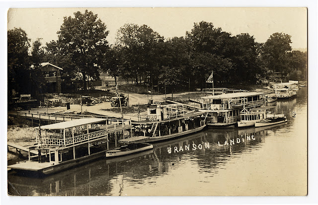
BRANSON LANDING - nearly 100 years ago! How things have changed!


Real photo postcard, c. 1925

Before the construction of the run-of-the-river hydroelectric Powersite Dam on the White River near Forsythe, float fishing was the primary sporting attraction for the Shepherd of the Hills Country. Lake Taneycomo, which filled in 1913, didn’t eliminate the celebrated Galena-to-Branson float, but it gave Branson and Hollister an advantage over Galena. The small lake was more compatible with larger, motorized watercraft than the shallow flowing James and White rivers in their native state.  By the mid-1920s the shoreline at Branson Landing was filled with larger motorized tour boats and smaller cruisers.  

The times - and Branson- are a-changin'! This shows just how different life a hundred years ago was in Branson. Motorized tour boats accommodated auto-delivered tourist who came to sightsee, not fish, float or commune with nature. Lake Taneycomo was compatible with Arcadianism but it opened the door to mass tourism. Today Branson Landing is a big modern shopping center, showing few traces of this earlier era.

COMING IN 2017: JAMES FORK OF THE WHITE: Transformation of an Ozark River.  
Sample pages from this new book can be seen at www.beautifulozarks.com 
Our earlier 'river book,' DAMMING THE OSAGE, can be seen at www.dammingtheosage.com

Tuesday, February 7, 2017

CHARLEY BARNES - JOHNBOAT BUILDER AND JAMES RIVER GUIDE


A lot has been written about the origin of the celebrated flat-bottomed wooden boats used on the James and White rivers. Outdoor writer Robert Page Lincoln wrote a long article on these boats, published in the March, 1948 issue of Fur-Fish-Game magazine, for which he extensively interviewed Galena river guide and boat builder Charley Barnes.

Robert Page Lincoln was a prominent writer on hunting and fishing in the 1930s through the 1950s. Seen here dressed like a running buddy of Ernest Hemingway, Lincoln observes Charley Barnes crafting a float boat. Lincoln wrote Barnes didn’t care for the name ‘johnboat.’


Charley Barnes guided Galena-to-Branson floats for forty years and built more than three hundred of the craft used in these trips. In a 1956 interview with Springfield News-Leader reporter Don Payton, Barnes said although he had “taken commercial floats on the Current River” and heard the term johnboat applied there, “We have never used that name here.” Barnes got in to the James River float business during its earliest commercialization, but soon realized, “‘the boats available weren’t big enough to accommodate occupants for much longer than a day.’ Barnes quickly came to the realization that greater cargo space was needed for tents, food, equipment, and other gear. The result was that Barnes, still working in Branson, fabricated a boat ‘about 20 feet long and a yard wide with a snub nose and flat bottom.’” The classic “float boat” created by Barnes and other Galena builders was more stable than “jack boats” as earlier long, narrow, flat-bottomed wooden boats were called. Johnboats couldn’t be as easily poled upstream but return by railroad made going upriver by boat unnecessary.

“This photo of Charley Barnes and his two brothers, Herbert and John, was taken in 1909 about the time that the Barnes float trip business at Galena, Mo., was at the height of its success. The bass shown in this photo are the same average size as those taken now. Reading left to right are Herbert, John, and Charley Barnes.” Caption from Robert Page Lincoln’s 1948 article in Fur-Fish-Game magazine.


COMING IN 2017: JAMES FORK OF THE WHITE: Transformation of an Ozark River.  
Sample pages from this new book can be seen at www.beautifulozarks.com 
Our earlier 'river book,' DAMMING THE OSAGE, can be seen at www.dammingtheosage.com
The caption from Robert Page Lincoln’s 1948 article reads:

Wednesday, February 1, 2017

Quest to Develop an Ozark River Boat

-->

Printed postcard, 1907
The photo appears to depict a family departing for an overnight outing. Boats could be rented from lodges, and self-guided trips were common throughout the float trip era. Both paddles and poles are evident. We wish this group, dressed for Sunday school, all the best as they prepare to drift down the beautiful James in these odd overloaded, probably unstable, pointed-bow skiffs, or punts, or whatever they were called.

The genesis of the square-ended, flat-bottomed boats specifically adapted for commercial floating on the James and White rivers is poorly documented. Many theories have been advanced as to how they were developed, and how they came to be called johnboats.

COMING IN 2017: JAMES FORK OF THE WHITE: Transformation of an Ozark River.  
Sample pages from this new book can be seen at www.beautifulozarks.com 
Our earlier 'river book,' DAMMING THE OSAGE, can be seen at www.dammingtheosage.com


Wednesday, January 18, 2017

Roaring River - the Back Story


In early settlement times, the spring pouring from a grotto beneath an overhanging bluff created a stream that powered water mills, once a common feature of Ozarks spring fed streams.  The last mill was converted into a hotel in 1905.  
Kansas City businessman, Roland M. Bruner bought the property that year and developed it into a vacation destination – Roaring River Camps and Hotel - during the 19-teens and twenties.  Trains brought visitors to Cassville and jitneys brought them the seven miles out to the rustic, Adirondacks style resort. 
The young lady pictured here is about to dive into the resort’s large swimming pool.  
 Bruner lost the property to foreclosure in 1928 and it was sold on the courthouse steps in Cassville. . St. Louis soap manufacturer, Thomas M. Sayman, bought the distressed property for $105,000 on November 16, 1928.  A few weeks later, December 5, he donated it to the state of Missouri.  
According to the nomination form for the National Register of Historic Places designation, both the Civilian Conservation Corps (CCC) and the Works Progress Administration (WPA) took part in developing Roaring River as a state park.  From 1933 through 1939 Company 1713 built 33 buildings, 17 acres of beach improvements, six acres of landscaping, and miles of roads and trails.
This information is taken from the Nomination Form:
CCC Company 1713 arrived in the area in June 1933 and remained until November 1939. During this period, the CCC enrollees developed the hatchery, built new cabins and other park buildings, developed hiking trails, and repaired the damages of a disastrous flood. The major achievement of WPA workers at Roaring River was the construction of an impressive three-story stone and timber Lodge. An important survival in the park is Camp Smokey, which contains four original CCC officers' barracks.

There is one historic district in the park: Camp Smokey-Company 1713 Historic District. Nominated as non-contiguous sites are the following: Deer Leap Trail, the lodge, the club house (bathhouse), the honeymoon cottage, the shelter and restroom (#'s 30 & 311, and the dam/spillway.

Camp Smokey-Company 1713 Historic District is significant because: it is the only surviving Civilian Conservation Corps Officers' compound in the Missouri state park system; it is a good example of the military character of these installations, modified by rustic architectural details.
The CCC buildings in Camp Smokey are unusual survivals, because of the normal practice of razing the barracks and related structures whenever a CCC company abandoned a particular camp.
See more vintage photos and learn more details of The Back Story of Roaring River Park in See the Ozarks.